Snow snow go away, come again some other day. Actually, we are nearing the end of our snowy weather!
At least, that’s what the models say for now…..
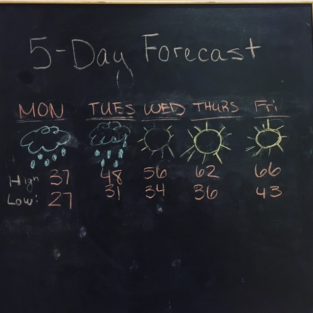
IN BRIEF:
As you can see above, it won’t be long until we get a reprieve!
Currently, the low pressure system that ended up dumping on us for the lest few days has turned into a high pressure system. In other words, the storm that is sitting over us is going to move!
Monday: 37/27 Slight Chance of Rain
Tuesday: 48/31 Slight Chance of Rain
Wednesday: 56/34 Sun!!!!!
Thursday: 62/36 Sun!
Friday: 66/43 Get your tan on because sun!!!
IN DEPTH:
So let’s talk about the low pressure system that hit us, shall we?
That low brought in a lot of moisture to the Denver-Metro area. I’ve heard a little over an inch of moisture hit our area. Which, I don’t have to tell you, is always welcome here.
Snow totals ran pretty high, like in the high country. Conifer, Nederlands, Evergreen….they all got dumped on! More than 2 feet of snow in some places! But in the Denver-Metro area, some saw as low as 5 inches. So, as far as the total that the models said was going to happen last Thursday, it was pretty dead on.
Which brings me to this week….
Currently we are sitting in what us meteorologists call a “blocking pattern.” A blocking pattern is a series of low and high pressures that basically align themselves in just the right way, that we stay in the same weather for a long period of time. I took a picture of it, but for some reason, now the media file which holds all my pictures isn’t working. It’s amazing how technology can get in the way sometimes!!!
So lucky for us, this blocking patter over us is going to get broken and we will start seeing those gorgeous spring-like days here soon!
I hope you all enjoy your week.
For more weather geekiness follow me on my social media handles!
Until then,
-M
